Shoreline Zoning and Native Vegetative Buffers
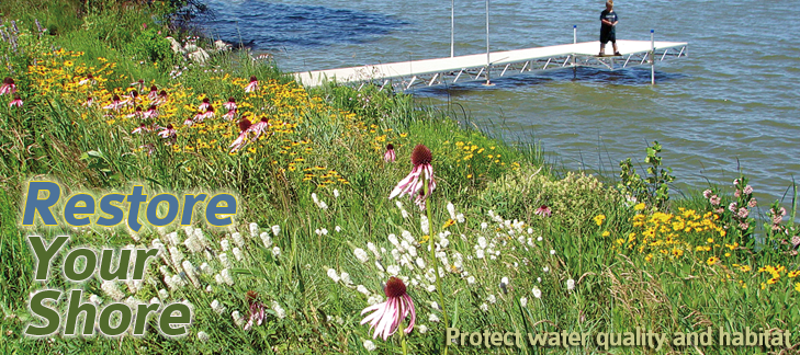
Image provided by Hubbard County Coalition of Lake Associations (COLA)
Description of Shoreland Zoning
The legislature of Wisconsin has delegated responsibility to the Counties to further the maintenance of safe and healthful conditions and prevent and control water pollution; to protect spawning grounds and fish and aquatic life; to control building sites, the placement of structures and land uses; and to preserve shore cover and natural beauty. Below are a few requirements pertaining specifically to preserving your shoreland that we want to remind you of.
The legislature of Wisconsin has delegated responsibility to the Counties to further the maintenance of safe and healthful conditions and prevent and control water pollution; to protect spawning grounds and fish and aquatic life; to control building sites, the placement of structures and land uses; and to preserve shore cover and natural beauty. Below are a few requirements pertaining specifically to preserving your shoreland that we want to remind you of.
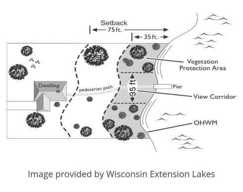
- Land that extends from the ordinary high-water mark of a navigable waterway to a minimum of 35 feet inland shall be designated as the vegetative buffer zone. Removal of vegetation in the vegetative buffer zone is prohibited. Some exceptions apply with approval from the Zoning Administers.
- No excavating and/or grading is allowed within the vegetative buffer zone, (unless its associated with a permitted use).
- Shoreline property owners are allowed to cut vegetation in your designated access and viewing corridor which can be up to 35’ wide for every 100’ of shoreline frontage. Lots with less than 100 feet of shoreline frontage are allowed an access and viewing corridor which is equal to 35% of the shoreline frontage.
- You need to obtain approval to cut trees and other vegetation outside of your designated access and viewing corridor. Contact Planning and Zoning to obtain approval.
- If you have any questions about the rules surrounding shoreland vegetation or other shoreland regulations please contact Chris Mrdutt at 715-346-1334 or by email at MrduttC@co.portage.wi.us.
OHWM = Ordinary High Water Mark
Why Native Vegetative Buffers?
The transition area between land and water on your shoreland property is extremely beneficial to the natural world and extremely vulnerable when it becomes manicured lawn. The Shoreland Stewardship Series publication states “Building a home and establishing a lawn can cause seven times the amount of phosphorus and 18 times the amount of sediment to enter the water compared to a natural shoreline.” (Link to document under Resources below) By law, land that extends from the ordinary high-water mark of a navigable waterway to a minimum of 35 feet inland shall be designated as a vegetative buffer zone. A vegetative buffer zone slows the rapid movement of water which carry excess nutrients and sediment from your property and prevents these contaminants from entering the nearby waterbody. The roots from the native vegetation help with bank stabilization and assist in preventing erosion from wave action. The taller native vegetation will also deter wildlife, especially Canada geese, from using your property as a restroom. You may want to place a border, rock for example, at the 35ft mark so you know where to stop mowing your lawn.
If you would like to restore your vegetative buffer and would like technical assistance please contact Tracy Arnold, Portage County Land and Water Conservation at 715-346-1326 or arnoldt@co.portage.wi.us. You may also be eligible for grant funding, see link below under Resources.
Shoreland Vegetation Surveys
Surveys of the shoreline vegetation around 29 lakes in Portage County were conducted in summer 2012 and summer
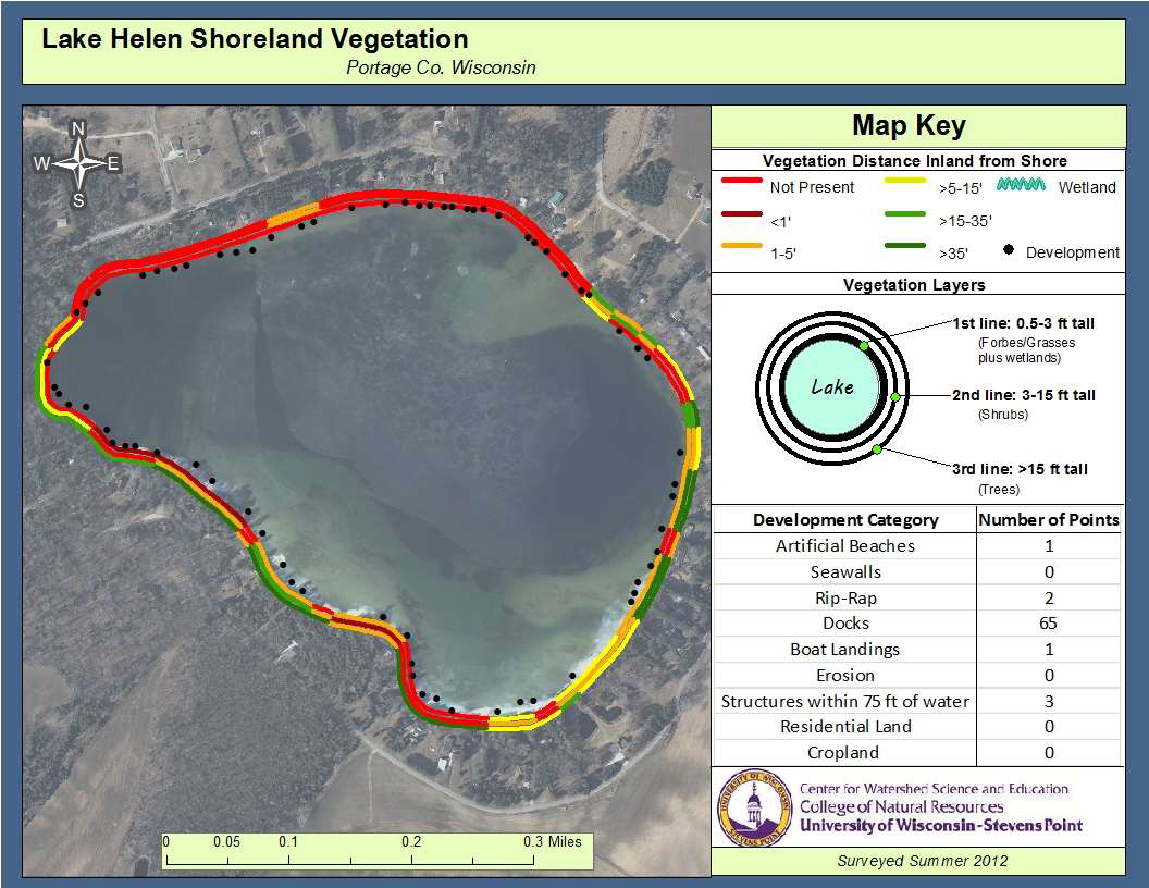
2013 by UWSP-Center for Watershed Science and Education, Lake Helen being one of these lakes. The results of the 2012 survey of Lake Helen’s shoreland are shown below. The ring nearest the lake depicts the shoreland vegetation depth inland from the water’s edge for the 0.5 to 3 foot tall vegetation (forbs and grasses), the middle ring depicts the depth of the vegetation that is 3 to 5 feet tall (shrubs), and the outer ring depicts the depth of the vegetation that is greater than 15 feet in height (trees). Approximately 300 feet of shoreland have improved around Lake Helen since the 2002-2003 survey (report available on County website); however, an estimated 98% of the shoreline needs restoration to improve water quality, provide habitat, and meet county and state shoreland standards. To view the complete report of the shoreline vegetation survey please see the link under “Resources”.
Shoreland vegetation survey around Lake Helen conducted in summer 2012.
Grant Funding is available
Portage County Planning and Zoning Department, Land and Water Conservation Division plans to apply for the WI DNR, Healthy Lakes and Rivers Grants annually. This grant provides up to $1,000 per Best Practice and up to $25,000 for an eligible applicant (Portage County) applying on behalf of multiple property owners. Grant applications are due in November with Best Practices installed the following year, if the grant is approved. Three hundred fifty square feet (350 sq ft) of native plantings are one of the selected Best Practices contained in this specific grant. More information provided under “Resources” below.
Portage County Planning and Zoning Department, Land and Water Conservation Division plans to apply for the WI DNR, Healthy Lakes and Rivers Grants annually. This grant provides up to $1,000 per Best Practice and up to $25,000 for an eligible applicant (Portage County) applying on behalf of multiple property owners. Grant applications are due in November with Best Practices installed the following year, if the grant is approved. Three hundred fifty square feet (350 sq ft) of native plantings are one of the selected Best Practices contained in this specific grant. More information provided under “Resources” below.
Grant Received in 2021 - 2022 Planning
Portage County Planning and Zoning Department, Land and Water Conservation Division DID receive the Healthy Lakes and Rivers grant for 2021, so Lake Helen will have two 350 sq ft. native plantings going in this year.
If you are interested in protecting your property and Lake Helen’s water quality through a Healthy Lakes and Rivers project for next year, please contact Tracy Arnold this summer to get plans in motion. Pre-application for 2022 projects are due September 1, 2021. You can email Tracy Arnold at arnoldt@co.portage.wi.us
RESOURCES (click on each site below for more information):
www.healthylakeswi.com/best-practices/#350
*Grant funding available annually, fact sheet of practice requirements, technical guide with a step by step process, decision tool worksheet to see if this practice will work on your property
www.dnr.wi.gov/topic/ShorelandZoning/documents/FH-429.pdf
* WI DNR, UW Extension, WI Lakes Partnership, River Alliance of WI brochure from 2003 regarding “The Shoreland Stewardship Series”
www.uwsp.edu/cnr-ap/UWEXLakes/Documents/ecology/shoreland/background/what_is_a_shoreland_buffer.pdf
*WI DNR, UW Extension, WI Lakes Partnership brochure from 1999 regarding “The Shoreland Stewardship Series”
https://www.co.portage.wi.us/home/showpublisheddocument?id=12174
Portage County 2012 Shoreland Survey Results provided by UWSP-Center for Watershed Science and Education


